Tuesday

2009 June -July Mt. Tihia Tokaanu swarm

The Mt. Tihia/Tokaanu Swarm of June/July 2009 was basically broken into 2 separate sequences north and south of the summit of Mt. Tihia.
The first swarm started on 11th June with 2 micro quakes and another on the 12th, but on the 14th the area really started to show evidence of activity in the southern flanks of the mountain. There were no quakes in the area on the 21st June, so I took the last quake on the 20th June at 14:18:23.8 as the break point before the 2nd sequence started on the 22nd more towards the northern base of the volcano and Tokaanu.
The 2nd sequence ran through to July 10th when activity petered off.
There were no quakes on the 4th, 6th and 7th July, but it would be hard to deny that this is one big swarm, broken down into 3 sequences or bunches, even with those gaps.

If you take in the earlier events of late May further south near Lake Rotoaira, from May 30th to June 8th at the northern end of Lake Rotoaira, which had 105 events and add them to the 2 other sequences ( based on date and location) that brings the total to 849 events between May 30th and 10th July in the area.
The map below shows all the events May 30th and 10th July using a combination of breaks in the dates (when there were no quakes) and also as the majority of the events moved as a group, to separate it down to 3 main bunches or sequences.


Data for the first swarm can be viewed in detail on the page. Rotoaira/Rotopounamu swarm

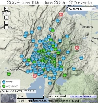
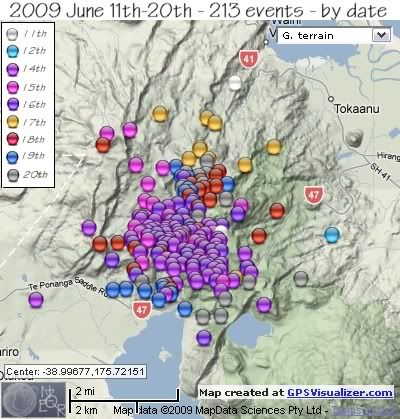
The second part of the overall swarm (or the first part of the Mt.Tihia /Tokaanu part) started on 11th June and ran through to 20th June, the map below shows all the events of this period.
First map shows location and magnitude and the second map breaks the swarm down on a daily basis ( magnitudes are not shown)
Monday

2009 June11th-20th Mt. Tihia/Tokaanu quakes

Mt Tihia Swarm June 11th to June 20th
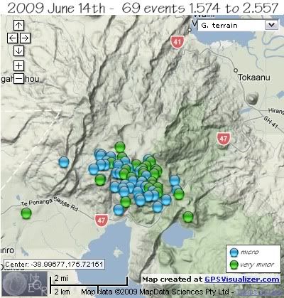
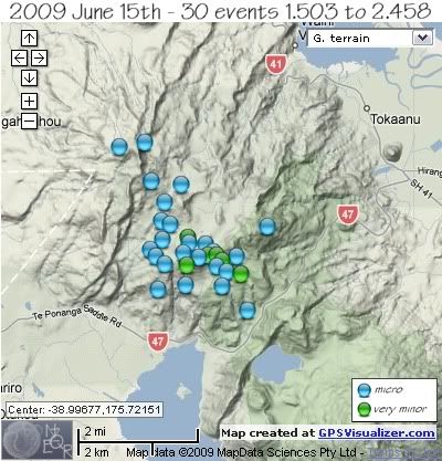
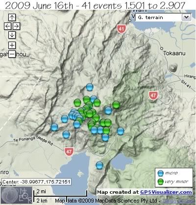
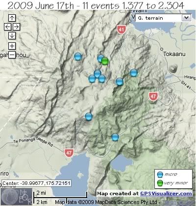
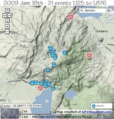
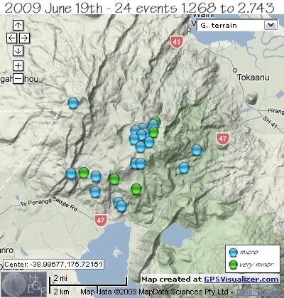
Each days data is followed by a map showing the locations and colour coded magnitudes
REF, LAT, LONG, TIME, DEPTH, MAG
3106655, -38.9605, 175.7334, 2009/06/11 19:48:54.3, 5, 1.315
3106417, -39.0006, 175.7289, 2009/06/11 09:24:46.7, 5, 1.592
3107301, -39.0011, 175.7668, 2009/06/12 23:28:51.7, 4, 1.4


June 14th – 69 events
REF, LAT, LONG, TIME, DEPTH, MAG
3108051, -39.0104, 175.7125, 2009/06/14 13:01:55.3, 5, 1.574
3108184, -39.0119, 175.7244, 2009/06/14 18:08:37.8, 5, 1.584
3108158, -39.0137, 175.7206, 2009/06/14 17:03:00.4, 5, 1.603
3108082, -39.0016, 175.7148, 2009/06/14 14:05:38.1, 7, 1.621
3108322, -38.9991, 175.6833, 2009/06/14 23:28:50.6, 6, 1.626
3108263, -39.0083, 175.7205, 2009/06/14 21:23:20.0, 5, 1.647
3108044, -39.0055, 175.7014, 2009/06/14 12:46:41.7, 5, 1.654
3108032, -39.0086, 175.7081, 2009/06/14 12:16:50.5, 5, 1.677
3108202, -39.0087, 175.7154, 2009/06/14 18:52:30.1, 8, 1.702
3108285, -39.0007, 175.7099, 2009/06/14 22:08:47.0, 7, 1.733
3108137, -39.0118, 175.7269, 2009/06/14 16:06:32.3, 5, 1.737
3108161, -38.9989, 175.704, 2009/06/14 17:11:16.9, 8, 1.741
3108185, -39.0128, 175.7197, 2009/06/14 18:10:06.2, 5, 1.752
3108164, -38.9984, 175.7241, 2009/06/14 17:18:07.6, 7, 1.753
3108123, -39.0161, 175.7286, 2009/06/14 15:41:41.7, 5, 1.779
3108018, -39.0018, 175.6979, 2009/06/14 11:42:49.5, 5, 1.783
3108111, -38.9971, 175.7012, 2009/06/14 15:11:56.9, 7, 1.789
3108047, -39.0003, 175.7034, 2009/06/14 12:53:36.3, 7, 1.807
3108239, -39.0046, 175.7231, 2009/06/14 20:26:22.1, 5, 1.824
3108169, -39.01, 175.7263, 2009/06/14 17:31:08.8, 5, 1.828
3108241, -39.0104, 175.7192, 2009/06/14 20:31:01.9, 5, 1.834
3108073, -38.9966, 175.7018, 2009/06/14 13:43:47.5, 5, 1.855
3108059, -38.9963, 175.7007, 2009/06/14 13:15:17.4, 7, 1.877
3108326, -39.0085, 175.7227, 2009/06/14 23:35:40.2, 5, 1.881
3108300, -39.0031, 175.7089, 2009/06/14 22:45:06.4, 7, 1.89
3108053, -39.009, 175.7119, 2009/06/14 13:05:26.3, 7, 1.896
3108134, -39.0063, 175.7165, 2009/06/14 16:01:46.9, 9, 1.903
3108023, -39.0035, 175.7105, 2009/06/14 11:58:08.6, 8, 1.905
3117095, -39.0061, 175.7371, 2009/06/14 18:14:25.8, 5, 1.916
3117089, -39.017, 175.71, 2009/06/14 18:15:02.2, 5, 1.916
3108150, -39.0027, 175.7203, 2009/06/14 16:30:34.4, 7, 1.919
3108235, -39.0003, 175.7096, 2009/06/14 20:19:00.4, 5, 1.925
3108034, -39.0078, 175.7131, 2009/06/14 12:21:49.3, 5, 1.939
3108196, -39.0117, 175.7248, 2009/06/14 18:37:48.7, 5, 1.949
3108135, -39.0004, 175.7013, 2009/06/14 16:03:04.1, 7, 1.954
3108042, -39.0134, 175.7328, 2009/06/14 12:38:17.4, 5, 1.955
3108175, -38.9972, 175.706, 2009/06/14 17:41:49.7, 7, 1.976
3108022, -39.0067, 175.721, 2009/06/14 11:53:16.4, 7, 1.978
3108055, -39.0097, 175.7381, 2009/06/14 13:07:30.0, 8, 1.98
3108061, -39.0033, 175.7118, 2009/06/14 13:17:39.9, 5, 1.984
3108197, -38.9993, 175.7129, 2009/06/14 18:39:59.9, 7, 1.993
3108128, -39.0027, 175.728, 2009/06/14 15:50:18.0, 8, 1.996
3108173, -38.9935, 175.7105, 2009/06/14 17:39:05.4, 9, 2.012
3108124, -39.0184, 175.6653, 2009/06/14 15:45:51.1, 5, 2.019
3108155, -39.0008, 175.7233, 2009/06/14 16:48:51.8, 8, 2.032
3108107, -38.9976, 175.7117, 2009/06/14 15:04:55.5, 8, 2.086
3108145, -39.0063, 175.7212, 2009/06/14 16:20:50.5, 7, 2.086
3108163, -39.008, 175.7259, 2009/06/14 17:14:42.9, 5, 2.094
3108046, -39.0038, 175.722, 2009/06/14 12:49:58.5, 7, 2.097
3108080, -39.0091, 175.7245, 2009/06/14 13:58:44.2, 8, 2.103
3108238, -39.0022, 175.7277, 2009/06/14 20:24:05.1, 5, 2.105
3108068, -39.0141, 175.7134, 2009/06/14 13:33:25.2, 7, 2.109
3108335, -39.0036, 175.7125, 2009/06/14 23:57:56.1, 8, 2.151
3108227, -39.0057, 175.701, 2009/06/14 19:58:47.5, 7, 2.155
3108066, -38.9995, 175.7065, 2009/06/14 13:25:50.5, 10, 2.17
3108100, -39.0088, 175.7288, 2009/06/14 14:42:08.9, 5, 2.208
3108120, -39.002, 175.7216, 2009/06/14 15:34:36.3, 7, 2.218
3108324, -39.0081, 175.7234, 2009/06/14 23:32:38.2, 5, 2.241
3108259, -39.0107, 175.7287, 2009/06/14 21:13:52.3, 5, 2.26
3108190, -39.0003, 175.7183, 2009/06/14 18:25:00.6, 6, 2.287
3108146, -39.0067, 175.7259, 2009/06/14 16:21:46.4, 7, 2.297
3108143, -39.0027, 175.7285, 2009/06/14 16:18:13.3, 5, 2.306
3108070, -39.0052, 175.7162, 2009/06/14 13:38:43.9, 8, 2.33
3108083, -39.0029, 175.7219, 2009/06/14 14:10:16.5, 6, 2.347
3108265, -39.0036, 175.7272, 2009/06/14 21:26:30.1, 7, 2.375
3108237, -39.0198, 175.7433, 2009/06/14 20:21:59.7, 5, 2.389
3108141, -39.0113, 175.7391, 2009/06/14 16:15:00.1, 8, 2.406
3108283, -38.9993, 175.7253, 2009/06/14 22:05:21.6, 5, 2.443
3108193, -39.002, 175.7133, 2009/06/14 18:31:51.4, 5, 2.557


June 15th – 30 events
REF, LAT, LONG, TIME, DEPTH, MAG
3108523, -38.9919, 175.7028, 2009/06/15 07:22:55.3, 5, 1.503
3108369, -39.0008, 175.7142, 2009/06/15 01:09:20.8, 7, 1.518
3108558, -39.0076, 175.7217, 2009/06/15 08:56:08.2, 5, 1.569
3108758, -38.9998, 175.7095, 2009/06/15 16:47:40.3, 5, 1.585
3108629, -39.0025, 175.7036, 2009/06/15 11:58:54.2, 5, 1.595
3108364, -38.9824, 175.6995, 2009/06/15 00:58:44.3, 5, 1.603
3108368, -38.9731, 175.6975, 2009/06/15 01:08:06.7, 5, 1.62
3108481, -38.9973, 175.7113, 2009/06/15 05:30:24.8, 5, 1.627
3108375, -38.9927, 175.7053, 2009/06/15 01:22:52.1, 8, 1.642
3108696, -39.0004, 175.726, 2009/06/15 14:35:00.7, 5, 1.646
3108477, -38.9975, 175.7165, 2009/06/15 05:20:55.0, 7, 1.65
3108553, -39.0136, 175.7296, 2009/06/15 08:42:35.3, 5, 1.672
3108900, -39.003, 175.7197, 2009/06/15 22:37:37.1, 5, 1.698
3108340, -39.0086, 175.7017, 2009/06/15 00:05:42.3, 5, 1.724
3114476, -38.9989, 175.699, 2009/06/15 07:23:29.9, 7, 1.736
3108361, -38.9832, 175.7087, 2009/06/15 00:53:25.8, 9, 1.753
3108685, -38.9933, 175.7356, 2009/06/15 14:10:08.9, 5, 1.757
3108371, -38.9875, 175.7036, 2009/06/15 01:12:37.3, 9, 1.849
3108676, -38.9965, 175.7031, 2009/06/15 13:54:23.8, 9, 1.908
3108374, -39.0074, 175.7101, 2009/06/15 01:18:08.3, 7, 1.921
3108825, -38.9741, 175.6896, 2009/06/15 19:22:16.6, 12, 1.932
3108820, -39.0043, 175.723, 2009/06/15 19:10:46.3, 5, 1.949
3108400, -39.0005, 175.701, 2009/06/15 02:16:41.9, 8, 1.993
3108672, -38.9993, 175.7186, 2009/06/15 13:39:46.8, 5, 1.995
3108470, -39.0002, 175.7199, 2009/06/15 05:11:58.5, 5, 2.07
3108419, -39.0027, 175.7105, 2009/06/15 03:13:54.3, 7, 2.091
3108341, -39.0049, 175.7273, 2009/06/15 00:08:59.4, 8, 2.119
3108339, -39.0002, 175.7172, 2009/06/15 00:03:27.0, 7, 2.233
3108362, -39.0015, 175.7216, 2009/06/15 00:55:28.3, 5, 2.284
3108363, -38.9961, 175.7109, 2009/06/15 00:56:43.6, 5, 2.458


June16th – 41 events
REF, LAT, LONG, TIME, DEPTH, MAG
3109059, -39.0284, 175.7227, 2009/06/16 05:09:14.3, 3, 1.501
3109033, -39.0077, 175.6913, 2009/06/16 04:06:05.9, 6, 1.554
3109295, -39.0133, 175.7269, 2009/06/16 13:30:56.5, 5, 1.557
3109097, -39.0052, 175.7252, 2009/06/16 06:15:24.4, 5, 1.619
3109083, -38.9998, 175.705, 2009/06/16 05:49:59.7, 7, 1.62
3109494, -39.0093, 175.7237, 2009/06/16 22:19:03.4, 5, 1.678
3109403, -39.0031, 175.709, 2009/06/16 18:01:03.2, 5, 1.687
3109131, -39.0033, 175.6985, 2009/06/16 07:20:10.7, 5, 1.74
3108984, -39.002, 175.706, 2009/06/16 02:04:59.3, 5, 1.776
3109192, -39.0014, 175.7036, 2009/06/16 09:29:10.0, 7, 1.805
3109089, -39.0022, 175.7079, 2009/06/16 06:03:17.2, 5, 1.843
3109111, -39.0061, 175.7071, 2009/06/16 06:39:44.1, 8, 1.845
3109118, -39.0098, 175.7377, 2009/06/16 06:53:00.3, 5, 1.872
3109139, -39.0007, 175.7069, 2009/06/16 07:38:37.4, 7, 1.878
3109212, -38.9924, 175.7187, 2009/06/16 10:07:53.5, 5, 1.909
3109038, -38.9859, 175.716, 2009/06/16 04:18:39.3, 10, 1.919
3109023, -39.0118, 175.6997, 2009/06/16 03:46:43.5, 9, 1.947
3108995, -38.999, 175.711, 2009/06/16 02:33:53.4, 9, 1.968
3108998, -38.9974, 175.7144, 2009/06/16 02:42:48.7, 7, 1.968
3109126, -39.0093, 175.719, 2009/06/16 07:11:17.1, 5, 1.993
3109145, -38.9987, 175.729, 2009/06/16 07:51:35.0, 5, 1.995
3109125, -39.0095, 175.7278, 2009/06/16 07:08:52.4, 5, 2.013
3109190, -39.0052, 175.7255, 2009/06/16 09:22:58.2, 5, 2.035
3109380, -39.0073, 175.7175, 2009/06/16 17:11:38.3, 5, 2.035
3109086, -39.0046, 175.7084, 2009/06/16 05:53:39.6, 7, 2.06
3109056, -39.0064, 175.7172, 2009/06/16 05:01:06.6, 5, 2.072
3109374, -39.0053, 175.7182, 2009/06/16 16:59:03.0, 5, 2.078
3108963, -38.9945, 175.7211, 2009/06/16 01:10:15.3, 10, 2.094
3109117, -39.0053, 175.7288, 2009/06/16 06:49:24.8, 5, 2.216
3108954, -38.9945, 175.7074, 2009/06/16 00:48:22.6, 8, 2.235
3109373, -38.9957, 175.7156, 2009/06/16 16:57:17.8, 5, 2.279
3108964, -39.0026, 175.7203, 2009/06/16 01:12:16.7, 7, 2.341
3109124, -39.0082, 175.7209, 2009/06/16 07:06:43.8, 5, 2.364
3109388, -39.0021, 175.7109, 2009/06/16 17:28:53.0, 5, 2.376
3109047, -39.0001, 175.714, 2009/06/16 04:36:18.9, 7, 2.417
3109138, -38.9953, 175.7345, 2009/06/16 07:36:19.9, 5, 2.464
3109248, -38.9993, 175.7097, 2009/06/16 11:32:59.5, 5, 2.593
3108961, -38.9998, 175.7182, 2009/06/16 01:05:50.8, 8, 2.643
3109025, -39.0005, 175.7162, 2009/06/16 03:51:17.4, 8, 2.87
3109245, -38.9929, 175.7139, 2009/06/16 11:28:57.8, 5, 2.886
3109123, -38.9977, 175.7136, 2009/06/16 07:04:28.0, 5, 2.907


June 17th – 11 events
REF, LAT, LONG, TIME, DEPTH, MAG
3109792, -39.0126, 175.7338, 2009/06/17 11:56:02.1, 5, 1.377
3109779, -39.0013, 175.7152, 2009/06/17 11:29:46.6, 5, 1.526
3109841, -38.9698, 175.7238, 2009/06/17 13:27:56.3, 6, 1.734
3109804, -38.9808, 175.7245, 2009/06/17 12:14:28.9, 5, 1.806
3114601, -38.9823, 175.7371, 2009/06/17 11:57:35.2, 5, 1.867
3109860, -38.9688, 175.7079, 2009/06/17 14:18:00.4, 7, 1.871
3109839, -38.9808, 175.7176, 2009/06/17 13:23:59.0, 7, 1.878
3109799, -38.9778, 175.7216, 2009/06/17 12:06:10.8, 5, 1.895
3109843, -38.9784, 175.7216, 2009/06/17 13:32:13.4, 6, 1.915
3109882, -38.9775, 175.7468, 2009/06/17 15:16:29.5, 5, 1.942
3109806, -38.9711, 175.7265, 2009/06/17 12:18:21.1, 5, 2.304


June 18th – 21 events
REF, LAT, LONG, TIME, DEPTH, MAG
3110439, -39.0155, 175.7091, 2009/06/18 15:49:04.0, 5, 1.125
3110512, -38.9828, 175.7132, 2009/06/18 19:06:34.1, 5, 1.174
3110546, -39.0146, 175.7088, 2009/06/18 20:36:03.0, 5, 1.188
3110301, -39.0158, 175.6917, 2009/06/18 09:17:15.5, 7, 1.205
3110452, -39.016, 175.7027, 2009/06/18 16:16:48.3, 5, 1.207
3110520, -38.9887, 175.7173, 2009/06/18 19:26:11.7, 5, 1.214
3117934, -39.0207, 175.7165, 2009/06/18 18:59:14.8, 5, 1.23
3117958, -39.0184, 175.7076, 2009/06/18 20:03:01.9, 5, 1.26
3110527, -39.0169, 175.7115, 2009/06/18 19:42:20.7, 5, 1.271
3110554, -38.9887, 175.7175, 2009/06/18 20:54:01.9, 5, 1.276
3110513, -38.9896, 175.7186, 2009/06/18 19:09:55.9, 5, 1.324
3110618, -38.992, 175.7191, 2009/06/18 23:42:59.6, 5, 1.343
3110533, -39.0165, 175.7115, 2009/06/18 20:02:25.9, 5, 1.372
3117442, -39.0155, 175.6961, 2009/06/18 08:51:26.9, 7, 1.439
3117946, -38.9897, 175.7162, 2009/06/18 19:06:49.7, 5, 1.451
3118020, -38.9858, 175.7173, 2009/06/18 23:53:09.8, 5, 1.452
3110535, -38.9855, 175.7149, 2009/06/18 20:09:04.2, 5, 1.559
3110309, -39.0034, 175.7107, 2009/06/18 09:42:46.5, 5, 1.65
3110622, -38.9874, 175.7307, 2009/06/18 23:54:05.1, 5, 1.702
3117925, -38.9986, 175.718, 2009/06/18 18:38:37.5, 5, 1.818
3110511, -38.988, 175.7157, 2009/06/18 19:02:59.0, 5, 1.876


June19th - 24 events
REF, LAT, LONG, TIME, DEPTH, MAG
3116982, -38.988, 175.7258, 2009/06/19 09:44:39.2, 5, 1.268
3116900, -38.9996, 175.7183, 2009/06/19 02:38:10.1, 7, 1.329
3110730, -39.0144, 175.7101, 2009/06/19 04:53:14.1, 7, 1.351
3110833, -38.9906, 175.7179, 2009/06/19 09:35:35.5, 5, 1.371
3110831, -38.9874, 175.7186, 2009/06/19 09:32:04.5, 5, 1.378
3110751, -39.0157, 175.7115, 2009/06/19 05:56:06.7, 5, 1.453
3110876, -38.9886, 175.723, 2009/06/19 11:29:38.1, 5, 1.454
3110824, -38.9935, 175.7207, 2009/06/19 09:18:09.8, 5, 1.469
3116926, -39.0045, 175.6992, 2009/06/19 04:53:52.4, 7, 1.584
3110749, -39.0035, 175.6873, 2009/06/19 05:53:35.3, 5, 1.587
3110948, -39.0014, 175.7418, 2009/06/19 14:17:07.4, 5, 1.588
3117488, -38.9866, 175.7218, 2009/06/19 16:27:53.8, 5, 1.656
3110737, -39.0105, 175.699, 2009/06/19 05:18:20.5, 5, 1.668
3110835, -38.989, 175.7212, 2009/06/19 09:41:46.6, 5, 1.682
3110957, -38.9771, 175.6883, 2009/06/19 14:35:01.3, 7, 1.737
3110945, -38.9918, 175.725, 2009/06/19 14:09:37.1, 5, 1.797
3111048, -38.9853, 175.7269, 2009/06/19 18:18:23.6, 5, 1.832
3111101, -38.9946, 175.7479, 2009/06/19 20:38:29.7, 5, 1.942
3111035, -38.9998, 175.721, 2009/06/19 17:48:42.1, 5, 1.999
3111008, -38.988, 175.7269, 2009/06/19 16:44:17.0, 5, 2.003
3111024, -38.9842, 175.728, 2009/06/19 17:22:17.6, 5, 2.098
3110880, -39.0092, 175.7188, 2009/06/19 11:38:47.7, 5, 2.103
3110754, -39.0055, 175.7081, 2009/06/19 06:03:25.6, 9, 2.237
3110763, -39.0031, 175.6935, 2009/06/19 06:26:15.6, 5, 2.743


June 20th – 13 events
REF, LAT, LONG, TIME, DEPTH, MAG
3118431, -39.0135, 175.7016, 2009/06/20 10:26:58.8, 5, 1.203
3111308, -39.0128, 175.7561, 2009/06/20 06:28:51.6, 5, 1.242
3111550, -38.9886, 175.7153, 2009/06/20 16:07:31.1, 5, 1.512
3111505, -38.9961, 175.721, 2009/06/20 14:15:45.8, 9, 1.568
3111311, -39.0182, 175.73, 2009/06/20 06:37:28.5, 5, 1.7
3111490, -38.9852, 175.721, 2009/06/20 13:36:14.6, 5, 1.758
3111309, -39.0228, 175.7226, 2009/06/20 06:31:00.1, 5, 1.829
3111508, -38.9846, 175.7235, 2009/06/20 14:23:47.2, 5, 1.87
3111326, -39.0135, 175.7382, 2009/06/20 07:06:35.1, 5, 1.894
3118015, -39.0228, 175.7286, 2009/06/20 08:32:47.7, 5, 1.987
3111519, -38.9845, 175.7166, 2009/06/20 14:55:04.9, 5, 2.009
3111713, -38.9815, 175.7238, 2009/06/20 23:06:13.6, 5, 2.029
3111518, -38.9875, 175.7224, 2009/06/20 14:52:38.5, 5, 2.19
3111506, -38.9914, 175.7305, 2009/06/20 14:18:23.8, 5, 2.272


data by geonet. maps by google maps. plots by highace using GPS Visualizer

Tuesday

1988-1989 Mt. Tihia/ Tokaanu quakes

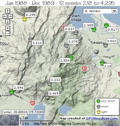
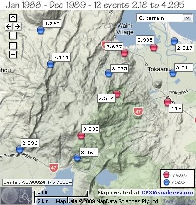
From January 1st 1988 to December 31st 1989 there were 12 earthquake events in the Mt. Tihia/Tokaanu area , 7 of them deeper than 156km.
Apart from two events on October 25th 1989, 20 minutes apart, the rest were scattered both on location and dates.
In 1988 the 5 earthquakes were on the Mt.Tihia side of the area, whereas in 1989 the 7 quakes were widespread. The largest quake in 2 years was the 4.295ML, located 80km deep at the base of Mt. Kuharua.
1988
REF. LAT, LONG, TIME, DEPTH, MAG
8460, -39.00349, 175.72081, 1988/02/02 04:30:50.6, 156, 3.232
25161, -38.95543, 175.77148, 1988/09/19 03:56:06.9, 179, 2.985
30178, -38.98078, 175.74553, 1988/11/17 16:44:43.2, 26, 2.554
30232, -38.95839, 175.75116, 1988/11/20 09:53:25.8, 224, 3.637
33410, -38.98523, 175.7814, 1988/12/23 12:40:59.3, 7, 2.18


1989
REF. LAT, LONG, TIME, DEPTH, MAG
36900, -38.96439, 175.6992, 1989/01/25 05:30:40.3, 183, 3.111
41438, -38.96921, 175.78511, 1989/03/13 12:09:37.4, 183, 3.011
64645, -38.94605, 175.69234, 1989/08/21 06:04:27.7, 80, 4.295
65783, -38.96951, 175.73994, 1989/08/27 20:15:20.1, 191, 3.075
70295, -38.95188, 175.78622, 1989/09/11 20:40:17.6, 179, 2.817
77202, -39.01096, 175.67767, 1989/10/25 01:31:17.1, 5, 2.896
77204, -39.01538, 175.71811, 1989/10/25 01:51:14.3, 5, 3.465


 Mt. Tihia/Tokaanu quakes 1988-1989

 Mt. Tihia/Tokaanu quakes 1988-1989 by year

data by geonet. map by google maps. plots by highace using GPS Visualizer

Monday

1987 Mt. Tihia/ Tokaanu quakes

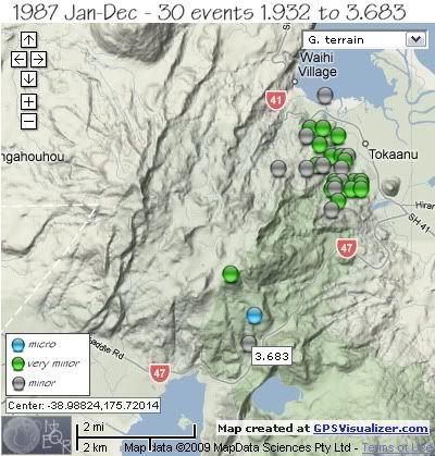
1987 has 6 events shown in the NZ Earthquake Catalogue, as follows;
REF, LAT, LONG, TIME, DEPTH, MAG
3886, -39.00062, 175.7141, 1987/01/27 20:29:52.1, 13, 3.324 *
3748, -38.9565, 175.73206, 1987/01/28 00:00:32.9, 12, 3.622 *
51330, -38.99681, 175.72377, 1987/05/20 02:18:01.2, 5, 2.432
51616, -39.0068, 175.73149, 1987/05/20 02:35:45.7, 2, 1.932
80581, -39.01381, 175.72992, 1987/10/14 10:35:20.3, 127, 3.683
94209, -38.95294, 175.75381, 1987/12/17 04:14:19.7, 5, 3.428


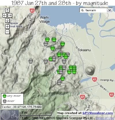
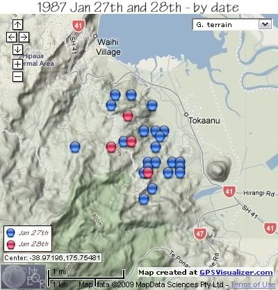
The following map and data on a swarm in 1987 is taken from a paper presented by Steven Sherburn and published in the New Zealand Journal of Geology and Geophysics 1993 Vol 36:61-68, entitled “The 1987 January Tokaanu earthquake sequence, New Zealand”.

"The 1987 Tokaanu earthquake sequence started at 1987 Jan 27 1923 UTC, and continued until Jan 28 0215 UTC, a duration of almost 7 hours. The largest earthquake in the sequence was 3.6ML Sixty-four earthquakes were recorded on the nearest seismograph during the sequence, and 26 of these were located (shown on maps below). The epicentres were centred 1-2 km northwest of the Tokaanu Power Station, at the northeastern foot of Kakaramea, and about 1-2 km east of the Waihi Fault "

The digital data used in this study come from the Taupo Seismic Network. The nearest seismograph was 12 km away from the centre of the sequence.
Details of the 28 earthquakes from the Tokaanu sequence for which digital waveform data were available.
Earthquakes numbered 4 and 9 were not located.
Those marked with an asterisk are a close match to those on the NZ Catalogue based on the size and approx. time, although the exact depth and location are slightly different.
REF, LAT, LONG, TIME, DEPTH, MAG
1, -38.975, 175.757, 1987/01/27 19:25:28.2, 5, 2.7
2, -38.979, 175.758, 1987/01/27 19:26:35.0, 5, 2.7
3, -38.974, 175.763, 1987/01/27 19:28:45.3, 5, 2.7
4, unlocated, 1987/01/27 19:29:00.0, , 2.5
5, -38.974, 175.765, 1987/01/27 19:30:58.6, 5, 2.8
6, -38.974, 175.757, 1987/01/27 19:32:15.4, 7.7, 2.7
7, -38.968, 175.761, 1987/01/27 19:35:37.9, 5, 3.1
8, -38.976, 175.756, 1987/01/27 19:45:12.9, 5, 2.8
4, unlocated, 1987/01/27 19:46:00.0, , 2.9
10, -38.971, 175.739, 1987/01/27 20:04:54.8, 5, 3.2
11, -38.961, 175.753, 1987/01/27 20:06:09.6, 5, 2.5
12, -38.975, 175.765, 1987/01/27 20:07:08.6, 5, 2.6
13, -38.969, 175.760, 1987/01/27 20:07:35.1, 3.2, 2.4
14, -38.976, 175.765, 1987/01/27 20:08:49.1, 5, 2.6
15, -38.963, 175.758, 1987/01/27 20:10:44.9, 5, 2.1
16, -38.968, 175.756, 1987/01/27 20:14:09.6, 3.7, 2.7
17, -38.981, 175.756, 1987/01/27 20:30:07.6, 5, 3.3 *
18, -38.968, 175.759, 1987/01/27 20:31:34.0, 3.6, 2.7
19, -38.976, 175.762, 1987/01/27 20:31:42.6, 5, 2.1
20, -38.961, 175.749, 1987/01/27 21:13:03.7, 5, 2.3
21, -38.971, 175.759, 1987/01/27 21:17:25.0, 5, 3.2
22, -38.974, 175.759, 1987/01/27 21:19:04.7, 4.6, 3.3
23, -38.970, 175.751, 1987/01/27 21:22:03.7, 5, 2.2
24, -38.963, 175.748, 1987/01/27 21:23:07.6, 7.2, 3.2
25, -38.970, 175.753, 1987/01/28 00:00:49.7, 5, 3.6
26, -38.965, 175.752, 1987/01/28 00:07:49.0, 5, 2.3 *
27, -38.976, 175.757, 1987/01/28 00:14:30.1, 5, 3.2
28, -38.971, 175.748, 1987/01/28 01:24:23.0, 5, 3.2


 Mt. Tihia/Tokanaau quakes 1987

 Tokaanu swarm Jan 27th and 28th sorted by magnitude

 Tokaanu swarm Jan 27th and 28th sorted by date

data by geonet. map by google maps. plots by highace using GPS Visualizer

Sunday

1986 Mt. Tihia/ Tokaanu quakes

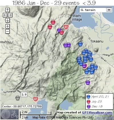
1986 has only one event shown in the NZ Earthquake Catalogue, a 3.9ML on 7th August down in the Lake Rotoaira Valley.
The following map and data on other events in 1986 is taken from a paper presented to the 17th NZ Geothermal Workshop 1995 called “ Earthquake Swarm Activity Beneath Tokaanu-Waihi Geothermal System, Lake Taupo, New Zealand” researched by M..P. Hochstein, S. Sherburn and J. Tikku. Geothermal Institute and Geology Department, University of Auckland, NZ, IGNS Wairakei, NZ
There are no co-ordinates for the epicenters of the quakes available, so the map and co-ordinates have been created by hand from a sketch map within the above report and match to the original map as close as possible. The epicenters were computed using the iterative Geiger method and the original digital data recorded by the Taupo Seismic Network., a network of six telemetred seismographs that operated around Lake Taupo between 1985 September and 1991 July.

All epicentres are located inside the low resistivity structure which outlines hot and thermally altered rocks in the upper 0.5 km of the Tokaanu-Waihi geothermal reservoir.
There is no data available on the magnitudes save for the maximum size in each swarm.
The April 20th-21st swarm had a sequence of 20 events. The maximum magnitude of 16 events on the 20th was 3.1 and the sequence lasted 1 hour. The later part of the swarm on the 21st had 4 events over a period of 6.5 hours.
The 3 events of the small July 23rd swarm occurred close to the thermally active Hipaua area, the 3 events occurred over a period of 1.5 hrs and the largest event was 2.6ML.
The 18th December swarm of 5 events was over a period of 10 hours and the largest quake was a 2.1ML.

The locations are marked on the map below, the dates shown by colour.
 Mt. Tihia/Tokaanu quakes 1986

data by geonet. map by google maps. plots by highace using GPS Visualizer

Saturday

1985 Mt. Tihia/ Tokaanu quakes

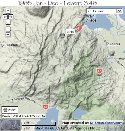
Only 1 event in the Mt. Tihia/Tokaanu area in 1985, a 3.48ML located west of the Hipaua Thermal Area on the 12th January.
 Mt. Tihia/Tokanaau quakes 1985
REF, LAT, LONG, TIME, DEPTH, MAG
1566657, -38.96, 175.72, 1985/01/12 09:48:19.0, 4, 3.48


data by geonet. map by google maps. plots by highace using GPS Visualizer

Friday

1984 Mt. Tihia/ Tokaanu quakes

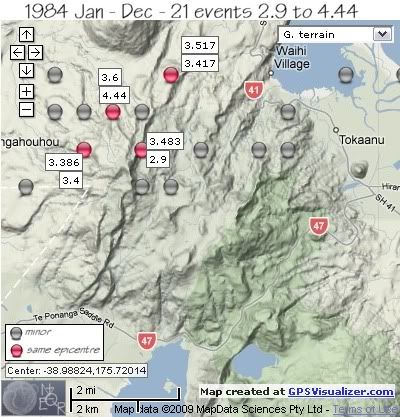
In 1984 there were 21 earthquakes in the Mt. Tihia/Tokaanu area.
There were 3 series of events of note, 6th March, 13th – 14th April and 25th-26th August.
 Mt. Tihia/Tokanaau quakes 1984

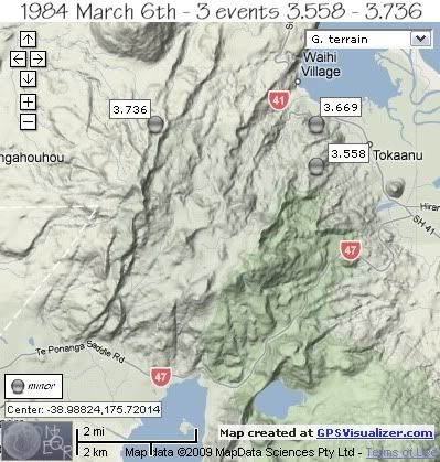
The first sequence of 1984 was on 6th March with 3 minor events within 49 minutes of each other, the first quake under the northern foothills of Mt. Tihia NW of Tokaanu, the 2nd quake further to the west under Mt. Kakaramea just west of the Waihi River and the 3rd quake back under the Mt. Tihia foothills, south of the first quake.
REF, LAT, LONG, TIME, DEPTH, MAG
1565057, -38.96, 175.75, 1984/03/06 05:01:50.2, 1, 3.669
1565059, -38.96, 175.7, 1984/03/06 05:11:01.0, 6, 3.736
1565061, -38.97, 175.75, 1984/03/06 05:50:07.7, 1, 3.558

 Mt. Tihia/Tokanaau quakes March 6th 1984

two further minor quakes in March and early April;
REF, LAT, LONG, TIME, DEPTH, MAG
1565072, -38.95, 175.67, 1984/03/09 21:54:08.7, 10, 3.717
1565146, -38.97, 175.74001, 1984/04/03 09:55:58.7, 5, 3.236


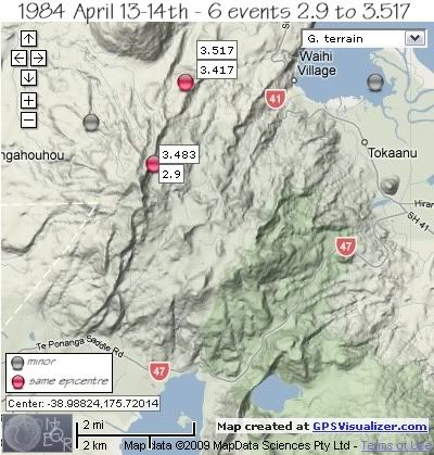
Swarm of 13th –14th April started on the 13th April with 2 quakes at the same location 45 seconds apart, SE of Mt. Kuharua, followed by another 15 hrs later under the summit of Mt. Kakaramea of 3.483ML.
It was another 9hrs before the next earthquake to the west of Mt. Kakaramea, followed by a 3.45ML in Tokaanu Bay and finished with a 2.9ML back at the location of the 3.483ML.
REF, LAT, LONG, TIME, DEPTH, MAG
1565184, -38.95, 175.71001, 1984/04/13 01:34:31.6, 6, 3.417
1565185, -38.95, 175.71001, 1984/04/13 01:35:16.4, 5, 3.517
1565189, -38.97, 175.7, 1984/04/13 16:49:58.7, 2, 3.483
1565191, -38.96, 175.67999, 1984/04/14 02:08:01.2, 5, 3.225
1565192, -38.95, 175.77, 1984/04/14 08:52:54.0, 2, 3.45
1565194, -38.97, 175.7, 1984/04/14 09:20:25.1, 5, 2.9

 Mt. Tihia/Tokanaau quakes April13-14th 1984

One quake located on the north side of Tongariro River Delta on the 15th, not part of either swarm.
1565197, -38.95, 175.78999, 1984/04/15 00:49:37.6, 5, 3.46


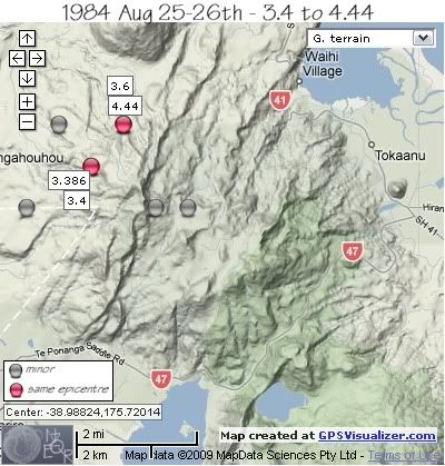
The swarm of 25th –26th August to the NW of Mt.Tihia, started with an isolated 3.888ML in the western foothills of Mt. Kakaramea, followed by a 3.7ML 2.2km to the NNE 2 ¼ hrs later. 33 seconds later the largest quake of 1984 ( the 4.44ML) hit, 2km east.
It was another 4 hrs before the 3.4ML, 2km south of the previous 3 events, followed 1 ½ hrs later by a 3.386ML at the same location.
The swarm finished rapidly, with 3 events within 3 minutes, 2 to the east of Mt.Kakaramea summit and one back at the same location as the 4.44ML.
REF, LAT, LONG, TIME, DEPTH, MAG
1565566, -38.98, 175.66, 1984/08/25 20:32:01.1, 5, 3.888
1565567, -38.96, 175.67, 1984/08/25 22:48:11.6, 5, 3.7
1565568, -38.96, 175.69, 1984/08/25 22:48:44.4, 5, 4.44
1565569, -38.97, 175.67999, 1984/08/26 03:55:57.4, 5, 3.4
1565570, -38.97, 175.67999, 1984/08/26 05:39:28.0, 5, 3.386
1565571, -38.98, 175.7, 1984/08/26 05:44:13.7, 5, 3.567
1565572, -38.96, 175.69, 1984/08/26 05:45:35.8, 5, 3.6
1565573, -38.98, 175.71001, 1984/08/26 05:46:04.6, 5, 3.82

 Mt. Tihia/Tokanaau quakes August 25-26th 1984

The year finished with one other event in December, 1km NNW of Mt. Tihia summit.;
REF, LAT, LONG, TIME, DEPTH, MAG
1565841, -38.97, 175.72, 1984/12/03 17:15:09.7, 11, 3.418


data by geonet. map by google maps. plots by highace using GPS Visualizer