Friday

1984 Mt. Tihia/ Tokaanu quakes

In 1984 there were 21 earthquakes in the Mt. Tihia/Tokaanu area.
There were 3 series of events of note, 6th March, 13th – 14th April and 25th-26th August.
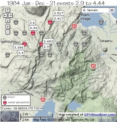
 Mt. Tihia/Tokanaau quakes 1984

The first sequence of 1984 was on 6th March with 3 minor events within 49 minutes of each other, the first quake under the northern foothills of Mt. Tihia NW of Tokaanu, the 2nd quake further to the west under Mt. Kakaramea just west of the Waihi River and the 3rd quake back under the Mt. Tihia foothills, south of the first quake.
REF, LAT, LONG, TIME, DEPTH, MAG
1565057, -38.96, 175.75, 1984/03/06 05:01:50.2, 1, 3.669
1565059, -38.96, 175.7, 1984/03/06 05:11:01.0, 6, 3.736
1565061, -38.97, 175.75, 1984/03/06 05:50:07.7, 1, 3.558
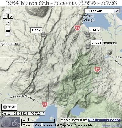
 Mt. Tihia/Tokanaau quakes March 6th 1984

two further minor quakes in March and early April;
REF, LAT, LONG, TIME, DEPTH, MAG
1565072, -38.95, 175.67, 1984/03/09 21:54:08.7, 10, 3.717
1565146, -38.97, 175.74001, 1984/04/03 09:55:58.7, 5, 3.236


Swarm of 13th –14th April started on the 13th April with 2 quakes at the same location 45 seconds apart, SE of Mt. Kuharua, followed by another 15 hrs later under the summit of Mt. Kakaramea of 3.483ML.
It was another 9hrs before the next earthquake to the west of Mt. Kakaramea, followed by a 3.45ML in Tokaanu Bay and finished with a 2.9ML back at the location of the 3.483ML.
REF, LAT, LONG, TIME, DEPTH, MAG
1565184, -38.95, 175.71001, 1984/04/13 01:34:31.6, 6, 3.417
1565185, -38.95, 175.71001, 1984/04/13 01:35:16.4, 5, 3.517
1565189, -38.97, 175.7, 1984/04/13 16:49:58.7, 2, 3.483
1565191, -38.96, 175.67999, 1984/04/14 02:08:01.2, 5, 3.225
1565192, -38.95, 175.77, 1984/04/14 08:52:54.0, 2, 3.45
1565194, -38.97, 175.7, 1984/04/14 09:20:25.1, 5, 2.9
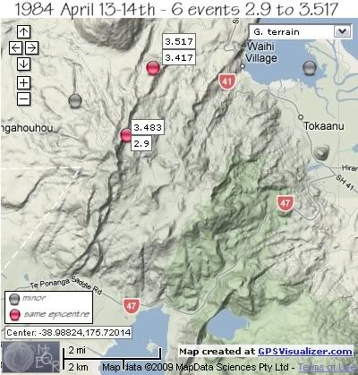
 Mt. Tihia/Tokanaau quakes April13-14th 1984

One quake located on the north side of Tongariro River Delta on the 15th, not part of either swarm.
1565197, -38.95, 175.78999, 1984/04/15 00:49:37.6, 5, 3.46


The swarm of 25th –26th August to the NW of Mt.Tihia, started with an isolated 3.888ML in the western foothills of Mt. Kakaramea, followed by a 3.7ML 2.2km to the NNE 2 ¼ hrs later. 33 seconds later the largest quake of 1984 ( the 4.44ML) hit, 2km east.
It was another 4 hrs before the 3.4ML, 2km south of the previous 3 events, followed 1 ½ hrs later by a 3.386ML at the same location.
The swarm finished rapidly, with 3 events within 3 minutes, 2 to the east of Mt.Kakaramea summit and one back at the same location as the 4.44ML.
REF, LAT, LONG, TIME, DEPTH, MAG
1565566, -38.98, 175.66, 1984/08/25 20:32:01.1, 5, 3.888
1565567, -38.96, 175.67, 1984/08/25 22:48:11.6, 5, 3.7
1565568, -38.96, 175.69, 1984/08/25 22:48:44.4, 5, 4.44
1565569, -38.97, 175.67999, 1984/08/26 03:55:57.4, 5, 3.4
1565570, -38.97, 175.67999, 1984/08/26 05:39:28.0, 5, 3.386
1565571, -38.98, 175.7, 1984/08/26 05:44:13.7, 5, 3.567
1565572, -38.96, 175.69, 1984/08/26 05:45:35.8, 5, 3.6
1565573, -38.98, 175.71001, 1984/08/26 05:46:04.6, 5, 3.82
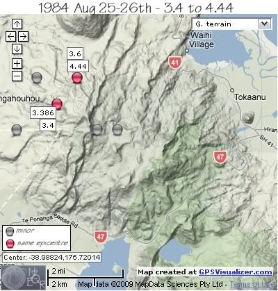
 Mt. Tihia/Tokanaau quakes August 25-26th 1984

The year finished with one other event in December, 1km NNW of Mt. Tihia summit.;
REF, LAT, LONG, TIME, DEPTH, MAG
1565841, -38.97, 175.72, 1984/12/03 17:15:09.7, 11, 3.418


data by geonet. map by google maps. plots by highace using GPS Visualizer
Thursday

1983 Mt.Tihia/Tokaanu quakes

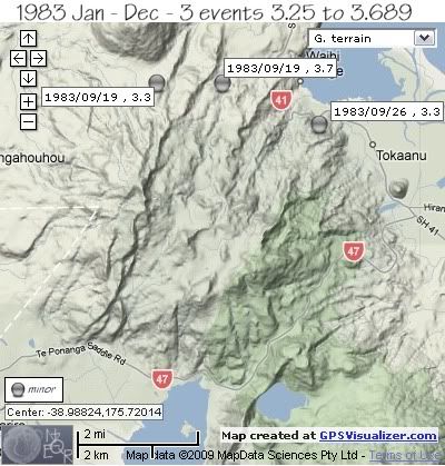
Between 1974 and 1983 there are no records of events in the area. In 1983 there were only 3 earthquakes, all in the northern area and all in September. Two quakes on the 19th September. one at the base of Mt. Kuharua, and the other near the Waihia River. The other quake , on 26th September was under the northern foothills of Mt. Tihia west of Tokaanu.
 Mt. Tihia/Tokaanu quakes 1983

REF, LAT, LONG, TIME, DEPTH, MAG
1564528, -38.95, 175.7, 1983/09/19 10:16:45.0, 12, 3.25
1564530, -38.95, 175.72, 1983/09/19 17:45:01.9, 12, 3.689
1564544, -38.96, 175.75, 1983/09/26 18:17:18.0, 12, 3.344


data by geonet. map by google maps. plots by highace using GPS Visualizer
Wednesday

1968-1974 Mt. Tihia/Tokaanu quakes

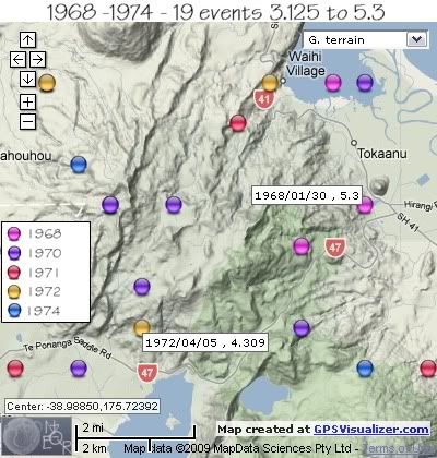
From 1968 to 1974 there were 19 earthquakes in the Mt.Tihia/Tokaanu area.
The largest quake was a 5.3ML on the 30th January 1968 in between the NE base of Mt. Tihia and Maunganamu Cone south of Tokaanu.
The next largest , and deepest quake was a 4.309ML on April 5th 1972 located on the southern flank of Mt. Tihia at 109km deep.
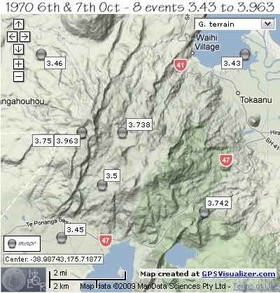
The only significant swarm during the 6 year period was a 8 event swarm in 1970 on the 6th and 7th October.
 Mt. Tihia/Tokanaau quakes 1968-1974 by location and year

REF, LAT, LONG, TIME, DEPTH, MAG
1549977, -38.98, 175.77, 1968/01/30 05:38:54.2, 12, 5.3
1549978, -38.99, 175.75, 1968/01/30 05:42:17.3, 12, 3.5
1550009, -38.95, 175.75999, 1968/02/18 15:05:22.0, 12, 3.538


The 1970 swarm of October 6th and 7th was widespread across the area but all within 6-7km of the center point of Mt. Tihia summit.
* same location
1553148, -39.02, 175.67999, 1970/10/06 00:55:33.2, 12, 3.45
1553149, -38.98, 175.69, 1970/10/06 02:42:26.3, 12, 3.75 *
1553153, -39, 175.7, 1970/10/06 03:38:42.7, 12, 3.5
1553155, -38.95, 175.77, 1970/10/06 09:11:00.2, 12, 3.43
1553157, -38.98, 175.69, 1970/10/06 15:56:53.2, 12, 3.963 *
1553158, -39.01, 175.75, 1970/10/06 16:01:18.4, 12, 3.742
1553162, -38.95, 175.67, 1970/10/07 00:12:02.1, 12, 3.46
1553168, -38.98, 175.71001, 1970/10/07 16:03:17.3, 12, 3.738

 Mt. Tihia/Tokanaau quakes 1970 by magnitude

Other quakes 1971 to 1974;
REF, LAT, LONG, TIME, DEPTH, MAG
1553414, -38.96, 175.73, 1971/02/10 06:12:56.6, 12, 3.711
1553418, -39.02, 175.78999, 1971/02/10 22:22:16.2, 12, 3.65
1553850, -39.02, 175.66, 1971/09/18 21:26:37.9, 12, 3.5
1554206, -39.01, 175.7, 1972/04/05 18:29:18.9, 109, 4.309
1554636, -38.95, 175.67, 1972/12/02 15:43:05.4, 12, 3.627
1554644, -38.95, 175.74001, 1972/12/07 22:52:55.3, 12, 3.125
1555487, -38.97, 175.67999, 1974/01/27 18:06:40.0, 12, 3.979
1555488, -39.02, 175.77, 1974/01/27 21:57:03.5, 12, 3.985


data by geonet. map by google maps. plots by highace using GPS Visualizer
Tuesday

1967 Mt. Tihia/Tokaanu quakes

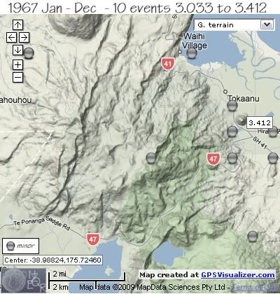
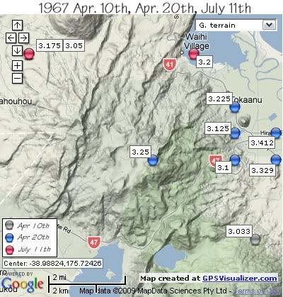
1967 was the first year when swarms were recorded in the Mt. Tihia/ Tokaanu area. There were essentially two sequences during 1967, the 1st with 6 events on April 20th under the NE base of Mt.Tihia south of Tokaanu, and one event centred under the summit of Mt.Tihia. The 2nd sequence of 3 events was on July 11th with 2 events located SW of Mt. Kuharua and 1 event in Waihi Bay, Lake Taupo off Waihi Village.
The other quake of 1967 was located under the lower NE slopes of Mt. Pihanga
The map below shows the locations;
 Mt. Tihia/Tokanaau quakes 1967 by magnitude

REF, LAT, LONG, TIME, DEPTH, MAG
* same location
1549534, -39.02, 175.78, 1967/04/10 14:36:26.3, 12, 3.033
1549547, -38.99, 175.78999, 1967/04/20 04:44:45.2, 12, 3.329
1549549, -38.99, 175.77, 1967/04/20 04:49:02.9, 12, 3.1
1549552, -38.98, 175.78999, 1967/04/20 05:56:24.9, 12, 3.412
1549553, -38.98, 175.77, 1967/04/20 06:04:20.6, 12, 3.125
1549555, -38.97, 175.77, 1967/04/20 07:22:31.6, 12, 3.225
1549556, -38.99, 175.73, 1967/04/20 08:07:57.0, 12, 3.25
1549671, -38.95, 175.67, 1967/07/11 06:22:55.9, 12, 3.05 *
1549673, -38.95, 175.67, 1967/07/11 08:19:53.0, 12, 3.175 *
1549674, -38.95, 175.75, 1967/07/11 08:54:44.0, 12, 3.2


The map below shows the same events separated by date
( colour of orbs denotes dates as per key on map)
 Mt. Tihia/Tokanaau quakes 1967 by date

data by geonet. map by google maps. plots by highace using GPS Visualizer
Monday

1941-1965 Mt. Tihia/Tokaanu quakes

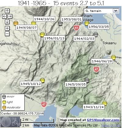
From 1941 to 1965 there were 15 earthquakes recorded within the study/search area of Mt. Tihia/ Tokaanu. The largest and deepest earthquake during the 24 year period was a 5.1 on the 7th August 1949 located SW of Mt. Kuharua.
The map below shows the locations and dates of the events, the colour of the orbs show the magnitude range (see key on map)

 Mt. Tihia/Tokanaau quakes 1941-1965

REF, LAT, LONG, TIME, DEPTH, MAG
* same location
2178505, -39, 175.7, 1941/05/30 06:05:06.0, , 3.7 *
2178506, -39, 175.7, 1941/05/30 18:54:32.0, , 2.7 *
1585334, -39, 175.75, 1942/04/30 09:09:42.4, 12, 4
1542420, -39.02, 175.77, 1943/11/24 14:28:35.0, 115, 4.25
1542569, -38.95, 175.69, 1944/10/26 21:29:36.5, 163, 4.85
1542698, -39, 175.7, 1945/10/12 04:18:38.9, 12, 4.2 *
1542802, -38.96, 175.7, 1946/05/22 18:05:24.2, 12, 4.1
1542848, -38.98, 175.78, 1946/06/28 11:50:20.0, 12, 4.333
1543568, -38.95, 175.72, 1949/07/19 17:07:16.6, 182, 4.55
1543584, -38.95, 175.67, 1949/08/07 22:10:05.0, 182, 5.1
1544767, -38.95, 175.72, 1953/08/01 11:52:12.0, 12, 3.7
1545358, -38.96, 175.7, 1956/01/13 07:18:34.9, 33, 4.175
1545397, -38.95, 175.75, 1956/03/05 01:21:43.7, 12, 4.1
1547739, -38.96, 175.75999, 1964/02/03 18:48:02.1, 12, 3.2
1548702, -39, 175.75, 1965/09/05 21:50:19.5, 119, 3.54


data by geonet. map by google maps. plots by highace using GPS Visualizer
Sunday

Rotoaira/Rotopounamu Introduction

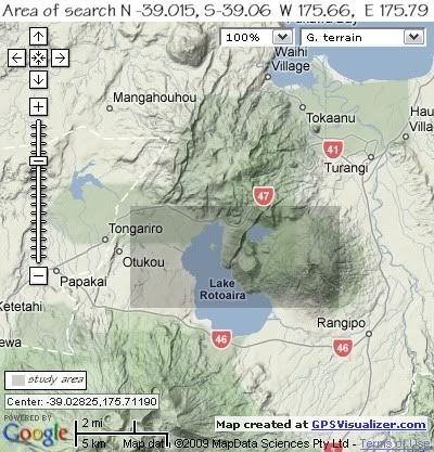
The parameters of Latitude and Longitude that have been used in this research/study have been set by the earthquake swarm events of 30 May to 2nd June 2009. They are Northern Latitude -39.015 (39° 0' 54" S), Southern Latitude -39.06 (-39° 3' 36" S), Western Latitude 175.66 (175° 39' 35.9994" E), Eastern Latitude 175.79 (175° 47' 23.9994" E).
Whilst there were earthquakes outside this study area during the same periods of time, I have kept to the perameters which cover the Western and Upper reaches of Lake Rotoaira, across the Ponanga Saddle between Lake Rotopounamu and Mt Tihia, to Mt Pihanga in the east for clarity.
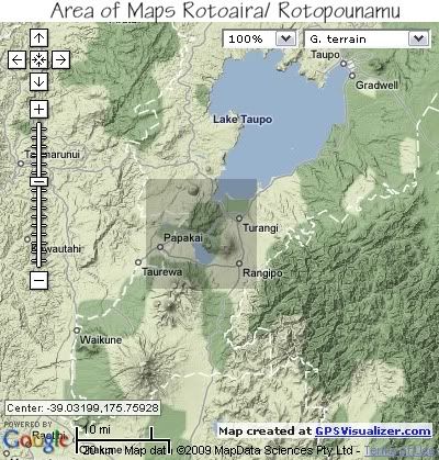
The maps below show the search areas as a darker shade.

 area that the maps cover

 area of search

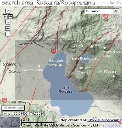
 area of search with geographical tags

Geography.
The Tongariro Volcanic Centre occupies the southern 65km of the Taupo Volcanic Zone and comprises three main volcanic complexes. In the north, the large cones of Pihanga (1,304m), Kakaramea (1,280m) and Tihia (1,147m) and smaller cones Puketopo (930m) and Pukemohono (795m) within what is known as the Rotopounamu Graben, all are extinct and are aligned NW-SE for about 10km.
The Rotopounamu Graben was formed approx. 2000 years ago after major eruptive acticity on the Tongariro Massif ceased. There are two un-named fault lines of uncertain age that run NNE-SSW on the east and west sides of Lake Rotopounamu. The lake may be consequent on ponding of drainage and so post date the faulting or it may have been an explosion crater.
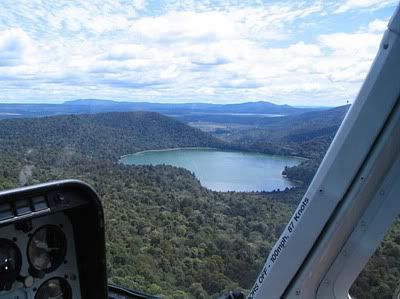
Lake Rotopounamu is approx 1m2 in area and with a maximum depth of 7.5m.
South of Lake Rotopounamu are two un-named cones known as Onepoto Craters, a minimum age of 20,000 years is suggested for all cones and domes in the Rotopounamu Graben area.

Deformation of the southern part of the Taupo Volcanic Zone in repect to the Kaimanawa Range to the east is estimated at an average rate of 2.1metres per thousand years.
Recent scientific work indicates that the earth's crust below the Taupo Volcanic Zone may be as little as 16 kilometres thick. A film of Magma 50 kilometres (30 mi) wide and 160 kilometres (100 mi) long lies 10 kilometres under the surface.
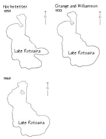
Local deformation within the Rotoaira/Rotopounamu Graben is known in historic times. Hochstetter’s 1864 sketch map of Lake Rotoaira shows two peninsulas extending into the lake, one at the southestern end and another at the northwestern end connecting with Motuopuhi Island.
In 1933 Grange and Williamson published a map of the area and the southeastern peninsula had disappeared but the northwestern peninsula persisted.
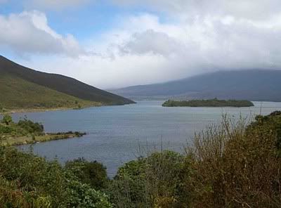
Since 1973 the end of the northwestern peninsula has become separated to form Motuopuhi Island. The area of Lake Rotoaira is therefore gradually extending as this part of the graben becomes further depressed.

 150 years of Lake Rotoaira deformation maps

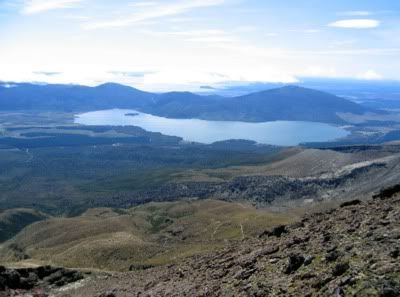
 Rotoaira from Tongariro Crossing trail

  Lake Rotopounamu from the air. Pic by ColinM

 view over Lake Rotoaira and Motuopuhi Island from the north. Pic by Bertu Burma

Saturday

Rotoaira/Rotoponamu Quake Chart

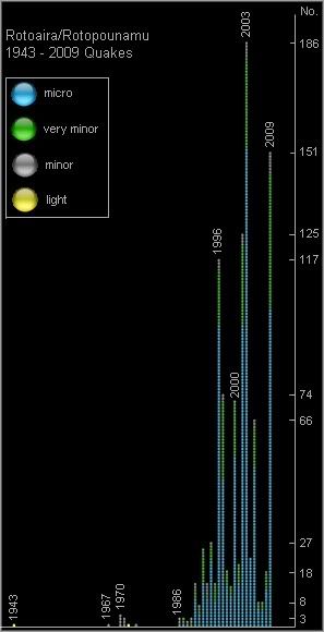
The bar chart below plots by year, all the earthquakes on the NZ Earthquake Catalogue held by Geonet for the years 1943 through to 2009, in the study/search area marked in the maps.
I acknowledge the New Zealand GeoNet project and its sponsors EQC, GNS Science and LINZ, for providing data used in this study.
 chart showing number of earthquakes per year 1943 to 1009 in the Rotoaira/Rotopounamu area

graph/plots by highace.