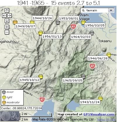
The map below shows the locations and dates of the events, the colour of the orbs show the magnitude range (see key on map)

REF, LAT, LONG, TIME, DEPTH, MAG
* same location
2178505, -39, 175.7, 1941/05/30 06:05:06.0, , 3.7 *
2178506, -39, 175.7, 1941/05/30 18:54:32.0, , 2.7 *
1585334, -39, 175.75, 1942/04/30 09:09:42.4, 12, 4
1542420, -39.02, 175.77, 1943/11/24 14:28:35.0, 115, 4.25
1542569, -38.95, 175.69, 1944/10/26 21:29:36.5, 163, 4.85
1542698, -39, 175.7, 1945/10/12 04:18:38.9, 12, 4.2 *
1542802, -38.96, 175.7, 1946/05/22 18:05:24.2, 12, 4.1
1542848, -38.98, 175.78, 1946/06/28 11:50:20.0, 12, 4.333
1543568, -38.95, 175.72, 1949/07/19 17:07:16.6, 182, 4.55
1543584, -38.95, 175.67, 1949/08/07 22:10:05.0, 182, 5.1
1544767, -38.95, 175.72, 1953/08/01 11:52:12.0, 12, 3.7
1545358, -38.96, 175.7, 1956/01/13 07:18:34.9, 33, 4.175
1545397, -38.95, 175.75, 1956/03/05 01:21:43.7, 12, 4.1
1547739, -38.96, 175.75999, 1964/02/03 18:48:02.1, 12, 3.2
1548702, -39, 175.75, 1965/09/05 21:50:19.5, 119, 3.54
data by geonet. map by google maps. plots by highace using GPS Visualizer

No comments:
Post a Comment