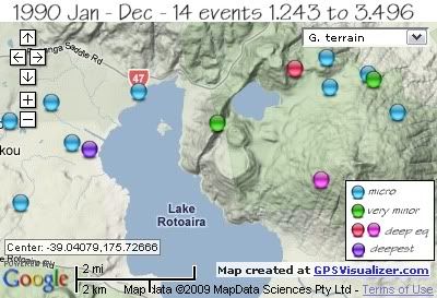
REF, LAT, LONG, TIME, DEPTH, MAG
98582, -39.01861, 175.75069, 1990/02/16 03:03:01.6, 115, 3.189
112591, -39.0459, 175.75883, 1990/03/04 23:41:49.1, 93, 2.583
119394, -39.03847, 175.68613, 1990/04/08 17:11:00.9, 244, 3.496
170426, -39.05144, 175.66441, 1990/10/29 21:08:45.9, 5, 1.617
170428, -39.03138, 175.66093, 1990/10/29 21:37:14.2, 5, 1.317
170953, -39.02436, 175.70148, 1990/10/31 11:45:30.3, 5, 1.41
171383, -39.03203, 175.72615, 1990/11/05 14:35:46.7, 5, 2.48
172173, -39.02681, 175.67422, 1990/11/05 18:41:32.9, 5, 1.248
177666, -39.03676, 175.68073, 1990/11/25 07:31:47.1, 5, 1.243
188530, -39.02008, 175.77379, 1990/12/19 16:06:26.2, 5, 1.894
182943, -39.02133, 175.77538, 1990/12/19 16:50:26.3, 5, 2.943
182978, -39.02925, 175.78308, 1990/12/21 05:12:29.5, 5, 1.338
188536, -39.01587, 175.76048, 1990/12/23 02:30:32.6, 5, 1.291
188537, -39.02323, 175.76161, 1990/12/23 07:07:32.7, 11, 1.316
data by geonet. map by google maps. plots by highace using GPS Visualizer

No comments:
Post a Comment