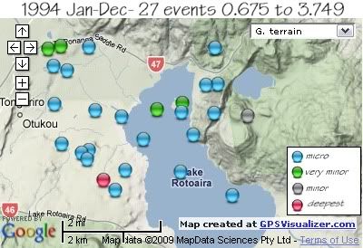
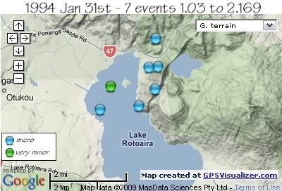
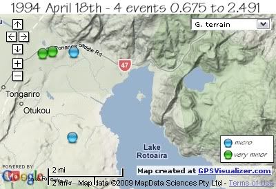
There was one moderate sized swarm on 31st January and a smaller swarm on April 18th of 4 events.
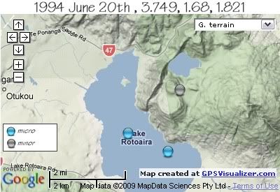
The largest quake was a 3.749ML on the 20th June (marked on the map as a grey coloured orb) and the deepest quake of 1994 was a 2.98 ML on the 8th January (marked on the map as a magenta coloured orb)

REF, LAT, LONG, TIME, DEPTH, MAG
542091, -39.05523, 175.68164, 1994/01/08 00:19:39.7, 148, 2.984
549301, -39.02171, 175.66289, 1994/01/22 21:47:36.0, 5, 1.194
552992, -39.04718, 175.67331, 1994/01/30 14:24:44.4, 5, 0.69
A ½ hr long swarm on 31st January, located in the northern reaches of Lake Rotoaira, from the western shore across to the south eastern side of Ponanga Saddle and the base of Mt. Tihia.
REF, LAT, LONG, TIME, DEPTH, MAG
552683, -39.03538, 175.7236, 1994/01/31 01:24:03.9, 5, 1.034
565660, -39.04311, 175.69696, 1994/01/31 01:25:23.7, 5, 1.766
553105, -39.03438, 175.7021, 1994/01/31 01:39:37.7, 5, 2.169
565715, -39.04196, 175.71553, 1994/01/31 01:45:07.0, 5, 1.098
554540, -39.02694, 175.72481, 1994/01/31 01:50:14.5, 5, 1.057
554281, -39.01614, 175.72406, 1994/01/31 02:05:18.5, 5, 1.03
565716, -39.02727, 175.72046, 1994/01/31 02:05:34.9, 5, 1.37

Three other events on March;
581784, -39.04644, 175.67632, 1994/03/24 11:40:48.0, 9, 1.919
588926, -39.03251, 175.7117, 1994/03/24 11:40:58.9, 8, 2.32
581798, -39.03475, 175.67859, 1994/03/25 08:51:51.6, 5, 1.095
On 18th April a small swarm spread over 4 hours, the two larger magnitude 2 events located just east of the Wairehu Canal south of the Te Ponanga Saddle Rd., then the 0.675ML 2.8km to the SSE and the final 0.998 ML back south of Te Ponanga Saddle Rd near the Otara Stream
REF, LAT, LONG, TIME, DEPTH, MAG
589481, -39.01564, 175.6656, 1994/04/18 00:57:50.4, 5, 2.491
589482, -39.01657, 175.66077, 1994/04/18 01:15:11.3, 8, 2.297
589632, -39.04892, 175.67535, 1994/04/18 02:45:15.8, 5, 0.675
591245, -39.01596, 175.67625, 1994/04/18 05:08:10.1, 5, 0.998

Two other events in May and June
599303, -39.05222, 175.6898, 1994/05/09 03:27:10.4, 12, 1.521
609567, -39.03279, 175.66325, 1994/06/12 22:22:09.5, 5, 1.405
The largest event in the area in 1994, occurred on the 20th of June a 3.749ML , 5km deep, under Onepoto Craters ( marked on map as a grey coloured orb) , with what appears as 2 aftershocks 3km to the SW, 1 hour and 2 ½ hrs later at a greater depth, under Lake Rotoaira.
REF, LAT, LONG, TIME, DEPTH, MAG
914020, -39.03612, 175.73625, 1994/06/20 05:43:24.7, 5, 3.749
921821, -39.05969, 175.73027, 1994/06/20 06:41:49.1, 9, 1.68
915940, -39.05267, 175.71103, 1994/06/20 08:12:25.3, 12, 1.821

Further quakes in 1994;
REF, LAT, LONG, TIME, DEPTH, MAG
643434, -39.05807, 175.68622, 1994/07/28 19:00:55.1, 5, 1.165
653024, -39.04446, 175.66583, 1994/09/16 00:18:27.6, 5, 1.524
653026, -39.03654, 175.68861, 1994/09/16 00:29:55.1, 5, 1.194
672879, -39.03513, 175.71124, 1994/10/21 06:44:06.0, 5, 1.113
710841, -39.02304, 175.66808, 1994/12/20 16:26:48.5, 13, 1.014
data by geonet. map by google maps. plots by highace using GPS Visualizer

No comments:
Post a Comment